

By Chandra Mohan
The Tropic of Cancer is one of the most significant geographical markers on Earth, and its passage through India makes our nation uniquely positioned at the intersection of tropical and subtropical climatic zones. At 23.5 degrees North latitude, this imaginary line runs through eight Indian states, creating a natural boundary that has shaped India’s climate, ecology, economy, and cultural landscape in profound ways. Understanding this geographical phenomenon requires us to look beyond mere coordinates—we must examine how this celestial marker influences the very foundations of Indian society, from agriculture to biodiversity to urban development.
What is the Tropic of Cancer?
The Tropic of Cancer is a circle of latitude that marks the northernmost point where the Sun appears directly overhead at noon. This occurs during the summer solstice, around June 20-21. The name originates from the zodiacal constellation that was directly above this latitude around 2,000 years ago, though due to Earth’s axial precession, the constellation has since shifted. The tropic exists as an imaginary line, yet its implications are entirely real—it represents the boundary of the tropics, beyond which the Sun’s rays never strike the Earth at a perfect right angle.
Geographically, the Tropic of Cancer circles the Earth, passing through 16 countries across Africa, Asia, and Central America. Within Asia, it passes through several nations, but India provides one of the most compelling case studies of how this geographical feature influences a vast and diverse population spanning over 1.4 billion people.
The Path Through India: Eight States and Their Characteristics
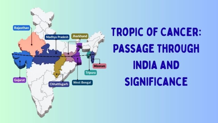
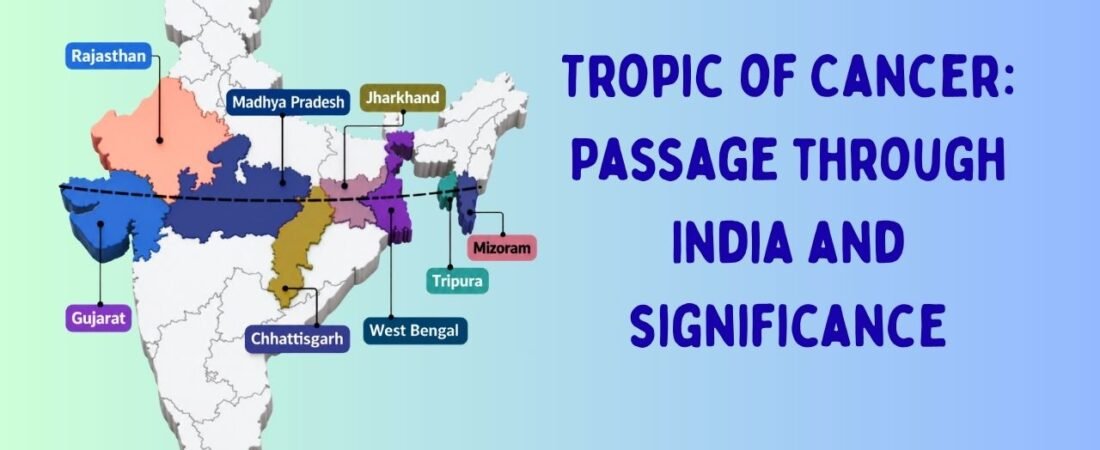
The Tropic of Cancer enters India in the western state of Gujarat and exits through the northeastern state of Mizoram, traversing a path of approximately 3,200 kilometers across the subcontinent. This journey takes the line through eight states, each with distinct geographical, climatic, and cultural characteristics.
Starting from the west, the line passes through Rajasthan, India’s largest state by area, where the arid and semi-arid landscape presents extreme temperature variations. Moving eastward, it traverses Gujarat, a state known for its entrepreneurial spirit and diverse ecosystems ranging from the salt marshes of the Rann to the deciduous forests of central Gujarat.
The line continues into Madhya Pradesh, often called the “heart of India,” where it passes through some of the nation’s most biodiverse regions. Chhattisgarh, India’s mineral-rich state, experiences the line’s passage through dense forests and mineral deposits that have shaped the state’s economy. Jharkhand, marked by its tribal heritage and mineral wealth, follows next, with the tropic passing through its eastern regions.
Moving into the Northeast, the line enters West Bengal, home to the Sundarbans, the world’s largest mangrove forest, and Tripura, characterized by its hills and valleys. Finally, the tropic exits Indian territory through Mizoram, a state of scenic beauty with significant annual rainfall.
Climatic Significance: The Tropical-Subtropical Boundary
The Tropic of Cancer’s most immediate significance lies in its role as a climatic boundary. North of this line, the climate shifts from tropical to subtropical and then to temperate zones. This division creates distinct meteorological patterns that govern rainfall, temperature, and wind patterns across India.
South of the tropic, India experiences a true tropical monsoon climate. The annual rainfall is abundant, humidity levels remain high, and seasonal variations are marked by distinct wet and dry periods. North of the line, the climate becomes increasingly continental, with greater temperature extremes, lower average rainfall in many regions, and different vegetation patterns.
This climatic division has profound implications for agriculture, which remains the backbone of India’s economy. The regions south of the tropic are suited to crops like cotton, sugarcane, and spices that thrive in tropical conditions. North of the line, wheat, rice in certain areas, and pulses dominate agricultural patterns. The Tropic of Cancer essentially marks the boundary between two agricultural civilizations within India, each with its own crop calendars, irrigation requirements, and farming traditions.
Ecological and Biodiversity Implications
The passage of the Tropic of Cancer through India’s interior creates a fascinating ecological transition zone. The line marks the boundary between distinct forest types—tropical deciduous forests to the south and subtropical/temperate forests to the north. This transition zone is incredibly rich in biodiversity, hosting species adapted to overlapping climatic conditions.
The Western Ghats and the Deccan Peninsula, lying south of the tropic, represent some of India’s most biodiverse regions. The tiger reserves, elephant corridors, and protected forest areas in states like Madhya Pradesh and Chhattisgarh owe their ecological richness partly to the climatic conditions established by their proximity to the tropic. The Central Highlands, through which the tropic passes, act as a transitional zone where tropical and subtropical species coexist.
The Northeast states through which the tropic passes, particularly in West Bengal and Mizoram, experience high rainfall due to monsoon patterns that are influenced by the latitude. The Sundarbans, home to the Bengal Tiger and countless aquatic species, exists in a unique ecological niche created partly by the climatic conditions near the Tropic of Cancer.
Geographical and Geological Significance
Beyond climate and ecology, the Tropic of Cancer’s passage through India has geological implications. The line passes through regions of significant mineral deposits. Chhattisgarh, for instance, is one of India’s richest mineral zones, with substantial reserves of iron ore, coal, and limestone—resources that have shaped the state’s development but also raised critical questions about environmental sustainability.
The terrain changes dramatically along the tropic’s path. In Rajasthan, it passes through the Thar Desert and semi-arid regions. In Madhya Pradesh, it traverses the Vindhya and Satpura ranges. In the Northeast, it passes through hilly, forested terrain. These geographical variations have historically influenced settlement patterns, trade routes, and cultural development.
Economic and Agricultural Implications
The Tropic of Cancer’s passage has significantly influenced India’s agricultural economy. The line roughly marks the boundary between India’s wheat belt in the north and the cotton-sugarcane belt in the central regions. This division reflects centuries of agricultural adaptation to local climatic conditions.
The irrigation patterns in states along the tropic show interesting adaptations to the climatic boundary. States like Madhya Pradesh and Chhattisgarh have developed sophisticated water harvesting and irrigation systems that account for the region’s transitional climate. The agricultural productivity in these regions depends significantly on understanding and working with the climatic patterns established by the Tropic of Cancer’s passage.
Water resources, including major rivers like the Narmada and the Mahanadi, flow through regions marked by the tropic’s presence. These rivers and their basins have been shaped by the climatic patterns associated with the latitude, making them vital for irrigation, power generation, and sustenance of millions.
Socio-Cultural Dimensions
From a sociological perspective, the Tropic of Cancer represents more than a geographical line—it marks cultural and demographic transitions within India. The states through which it passes show variations in cultural practices, food habits, and even social structures that correlate, to some extent, with the climatic and ecological differences established by the latitude.
The tribal populations in central India, particularly in Madhya Pradesh, Chhattisgarh, and Jharkhand, have developed lifestyles intimately connected to the forest ecosystems that characterize regions near the tropic. Their agricultural practices, food systems, and traditional knowledge represent generations of adaptation to the specific climatic and ecological conditions of these zones.
The Northeast states through which the tropic passes show distinct cultural characteristics influenced partly by their climatic conditions. The high rainfall supports specific agricultural practices and forest-dependent livelihoods that have shaped the cultural identity of communities in West Bengal, Tripura, and Mizoram.
Urban Development and Infrastructure Planning
The Tropic of Cancer’s passage through India has implications for modern urban planning and infrastructure development. Cities and towns along or near the line must account for the climatic transition. Cities in Gujarat and Rajasthan, for instance, face water scarcity challenges exacerbated by the region’s position near the arid zones, while cities in the Northeast face high rainfall and flooding challenges.
Infrastructure like highways, railways, and power transmission lines that cross the tropic must be designed to withstand the varying climatic conditions on either side. The climatic transition also influences building design standards, water management systems, and agricultural extension services across these states.
Conclusion: A Line That Defines
The Tropic of Cancer, running through eight Indian states at 23.5 degrees North latitude, is far more than an astronomical reference point. It is a geographical boundary that has shaped India’s climate, ecology, economy, and society in fundamental ways. From determining which crops are grown to which forests thrive, from influencing water availability to shaping cultural practices, this imaginary line creates real divisions and transitions across the Indian landscape.
Understanding the Tropic of Cancer’s significance helps us comprehend India’s complexity—a nation where tropical and subtropical climates, tropical and temperate forests, and diverse economic systems coexist within a relatively compact geographical space. As climate change and development pressures mount, understanding how this geographical boundary influences India’s regions becomes increasingly important for sustainable development and resource management.
The Tropic of Cancer passes through India not as a barrier but as a zone of transition, reminding us that our nation’s strength lies in its ability to accommodate and integrate diverse climatic, ecological, and cultural zones into a cohesive whole.
Disclaimer
This article is written for educational and informational purposes to enhance geographical awareness and understanding of India’s diverse climatic and ecological zones. The content draws from established geographical, meteorological, and ecological knowledge. While every effort has been made to ensure accuracy, geographical and climatic data can vary based on recent research and evolving climate patterns. Readers are encouraged to consult additional authoritative sources, including publications from the Indian Meteorological Department, National Geographic, and peer-reviewed geographical journals, for specialized or current data. The author does not claim absolute authority on all interpretations of the Tropic of Cancer’s socio-economic impact, as these remain subjects of ongoing academic research and debate. This content should not be used as the sole basis for making decisions related to land use, agriculture, or environmental policy without consulting relevant experts and government authorities.